The old occupation of surveyor in New France
Was your ancestor an “arpenteur,” or surveyor? Learn what this occupation was like in New France and Canada.
Cliquez ici pour la version en français
L’Arpenteur | The Surveyor
The surveyor's role involved the critical task of measuring and mapping the land, using a combination of specific measuring and optical instruments.
Initially, the instruments used for these measurements were quite rudimentary, relying mainly on manual tools like ropes and chains. In 1620, the first survey chain, known as Gunter's Chain, was introduced in Canada. It was approximately 20 meters (66 feet) long and consisted of 100 rings or links. Although measuring with a chain lacked precision, it provided a quick and practical estimate of distances. This method also allowed surveyors to use the Pythagorean theorem to calculate right angles, enhancing their ability to map the land accurately.
Measuring the width of a river by triangulation in the 16th century (Wikimedia Commons)
Gunter’s Chain (Library of Congress)
Over time, the chain was replaced by the more precise steel tape, and eventually by telescopic devices like the telemeter (invented in 1821) and the tacheometer (invented in 1835). Alongside these telescopic instruments, surveyors also used tools such as the theodolite (for measuring angles), the compass (for determining location and magnetic bearing), and other equipment like levels and barometers for taking vertical measurements.
Measurement of the area of land; surveying techniques (from the Larousse du XXème siècle, Wikimedia Commons)
Example of a chainage report by surveyor Jean Guyon in 1675 (Bibliothèque et Archives nationales du Québec)
In New France, surveying was essential to the seigneurial system, as the state needed accurate measurements to distribute land to seigneurs, landowners, or directly to censitaires (tenant farmers). The professional surveyor was the only person qualified to practice this trade. Between 1626 and 1760, there were at least 78 surveyors active in Canada. From 1663 to 1760, the intendant of the colony was responsible for issuing surveying commissions. To become a surveyor, one had to obtain a certificate from Father Allioux, a professor of hydrography at the Jesuit College of Quebec, and the sworn surveyor Dubeau, confirming the candidate's knowledge and experience.
Surveyors' commissions could be geographically limited, applying only to specific areas like a seigneury, a region, or a particular government. After completing a land survey, the surveyor typically prepared a detailed report, sometimes including a map. Surveyors were also frequently called upon to measure land in order to resolve legal disputes.
The surveyor was sometimes referred to as a "mesureur" or mesurer, highlighting the role's focus on precise measurement.
In 1763, following the British Conquest, the position of Surveyor General was established, with the primary responsibility of overseeing the surveying of Crown land. In 1785, the first official surveying regulations were introduced, outlining new procedures that surveyors were required to follow—many of which remain in use today. These regulations standardized the format of survey reports and required surveyors to maintain a detailed register of their work, which would become public property upon their death.
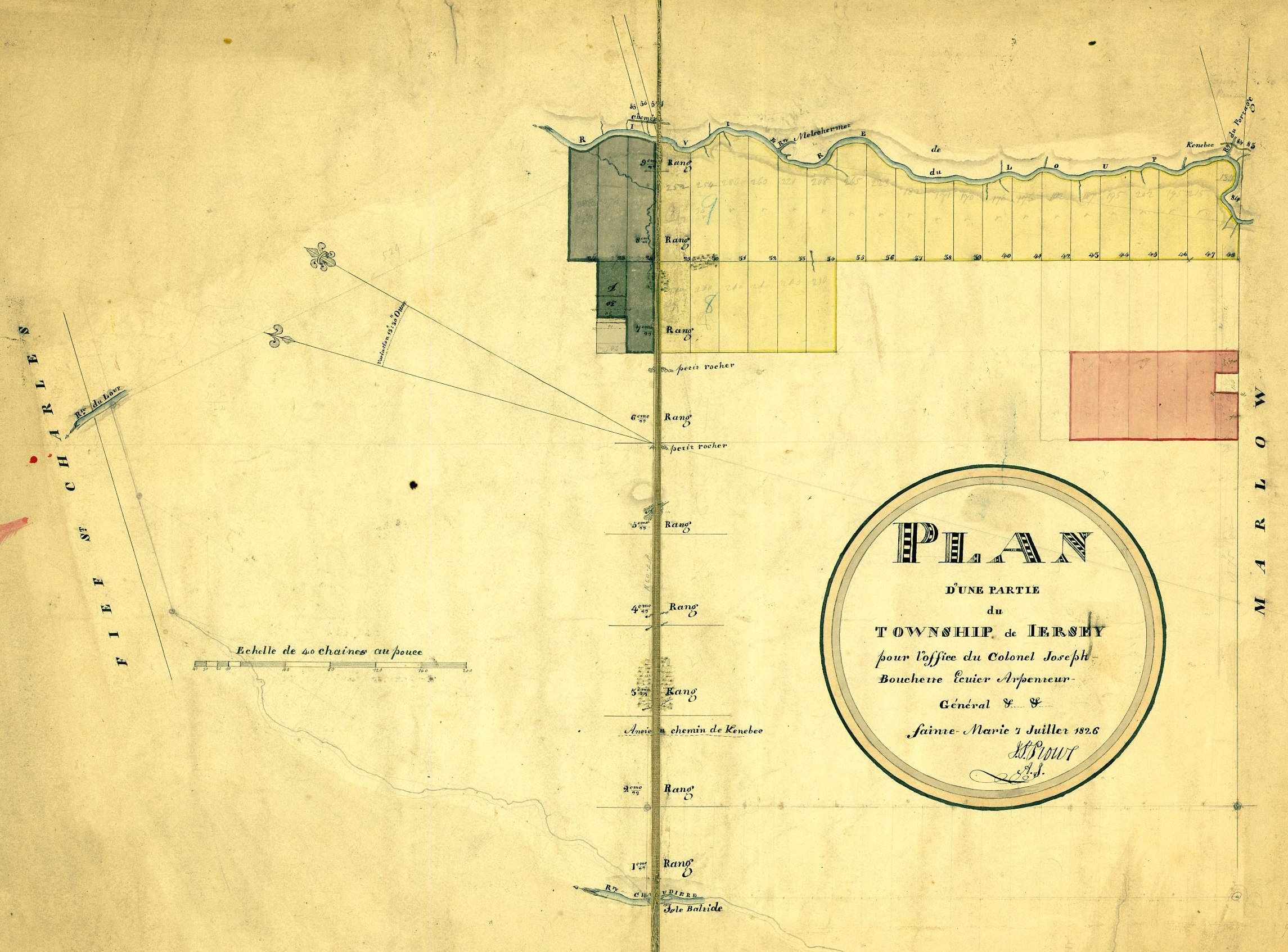
Plan of a portion of the township of Jersey in 1826 for the office of Colonel Joseph Bouchette, Surveyor-General (Bibliothèque et Archives nationales du Québec)
Today, the French term "arpenteur-géomètre" (land surveyor) is more commonly used, although it didn't become widespread until the 19th century.
Bibliothèque et Archives nationales du Québec hosts a valuable database called « Inventaire des procès-verbaux des arpenteurs de la région de Québec, 1673-1891 » (Inventory of Surveyors' Reports in the Quebec Region, 1673-1891).
Men who practiced the profession of surveyor:
“Architecture & Geometry & Surveying” (1547 drawing by Johannes Petreius, Wikimedia Commons)
Jean Olivier Arcand, Pierre Arseneau/Arsenault, Louis Bacon, François Badeau, Charles Basset, Toussaint Beaudry, Jean Baptiste Bélisle, Hilaire Bernard de Larivière, Noël Bonhomme dit Beaupré, Louis Marin Boucher dit Boisbuisson, Joseph Bouchette, Jean Bourdon, Jean Boutin, Joseph P. Bureau, Louis Cantin, Louis Champoux, René de Couagne, Charles Deblé/Desbleds, Jean Baptiste Demers, Pierre Déry, Maurice Desdevens de Glandon, Antoine Desmarais, Jean-Baptiste Duberger, Jean Duboc/Duboct, Janvier Dufresne, Joseph Narcisse Duval, Benjamin Écuyer, François Fortin Jérémie, Joseph Fortune, Charles Fournier, Charles François, Jean Gaudet, Amable Gipoulou/Gibouleau, Jean Baptiste Grenier, Jean Guyon du Buisson, Joseph Hamel, Jean François Hamelin, Samuel Holland, Pierre Janson dit Lapalme, Jean Baptiste Janvrin dit Dufresne, Paul Jourdain dit Labrosse, François de Lajoue, Adolphe Larue, Jean Baptiste Larue, Jean-Baptiste Lefebvre dit Angers, Michel Lefebvre, Charles Lefrançois, François Legendre, Hilarion Legendre, Louis Legendre, François Lemaître dit Lamorille, Alexis Lemoyne/Lemoine, Germain Lepage, Jean Lerouge, Pierre Noël Levasseur, Charles Manuel, Pierre Marcouiller, Jeremiah McCarthy, Gilles Papin, Étienne Parent, Jean Péladeau, Pierre Pépin dit Laforce, Jean-Baptiste Perreault, Louis Perreault, Ignace Plamondon, Ignace Plamondon dit Lafleur, Jean Plamondon, Owen Quinn, Joseph Raymond, Patrice Renaud dit Blanchard, William Sax, Alexander Stevenson, Charles Vallée, William Ware, Joseph Weilbrenner
Enjoying our articles and resources? Consider showing your support by making a donation. Every contribution, no matter how small, helps us pay for website hosting and allows us to create more content relating to French-Canadian genealogy and history.
Thank you! Merci!
Sources:
Centre national de ressources textuelles et lexicales, lexicographie: arpenteur (https://www.cnrtl.fr/definition/arpenter).
Claude Lajeunesse, "Arpentage," l'Encyclopédie Canadienne, Historica Canada (https://www.thecanadianencyclopedia.ca/fr/article/arpentage), article published 7 Feb 2006; last updated 4 Mar 2015.
Jérémie Lévesque-St-Louis, “Retracer le territoire, tracer le pays : l'arpenteur-général de la couronne britannique Joseph Bouchette et l'appropriation du territoire canadien (1791-1840),” thesis presented for a master's degree in history, June 2021, Université du Québec à Montréal (http://archipel.uqam.ca/id/eprint/15597).
"Inventaire des procès-verbaux des arpenteurs de la région de Québec, 1673-1891 : Présentation," Bibliothèque et Archives nationales du Québec (https://www.banq.qc.ca/archives/genealogie_histoire_familiale/ressources/bd/recherche.html?id=TERRE_ARPENTAGE#:~:text=Bien%20que%20l'on%20reconnaisse,v%C3%A9rifier%20la%20pr%C3%A9cision%20des%20boussoles).


